Maps help public health officials fight malaria, West Nile Virus

When it comes to describing a scenario, a picture is worth a thousand words—and may also help save thousands of lives. Thanks to research at SDSU, public health officials can use satellite data to anticipate outbreaks of West Nile virus in South Dakota and malaria in the highlands of Ethiopia.
Yi Liu, associate professor of computer science, collaborated with senior scientist Michael Wimberly of the Geospatial Sciences Center of Excellence to create a web atlas that gives public health officials a "heads-up" as to where and when mosquito-borne diseases might strike.
Researchers combine remote-sensing data—including temperature and rainfall—with sophisticated software modeling. The advance warning helps health officials put the disease-fighting resources and people where they are needed most.
Building a software framework
The collaboration began in 2009 when Wimberly asked Liu to help build a web atlas with which his team could disseminate their maps. Using her experience as a software engineer, Liu and her students developed the framework of the web atlas to support specific products.
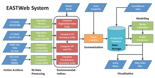
One such product allows Wimberly and his team to use the framework to post maps that are part of Epidemiological Applications of Spatial Technologies or EASTweb.
Improving product performance
Wimberly and his team used to rely on ArcGIS, a common commercial software, and Python programming code to make the maps available online. "They didn't have a product to handle the entire process," Liu said. Six undergraduate students and four graduate students have worked on the project during the last five years.
Liu and her students studied what had been done to get "a good picture of the typical way of processing the images."
After one year, Liu and her team automated the process of downloading online remote-sensing archives and processing them. This enabled scientists to compute and summarize environmental indices, which can then be saved to a database.
The computer science team replaced Python code with Java programing language, but retained ArcObjects, a component of ArcGIS. Java provided what Liu called "a nice user interface," but "the performance was not stable."
Supported by a Joseph P. Nelson scholarship, undergraduate Isaiah Snell-Feikema replaced the ArcObjects with a Geospatial Data Abstraction Library, GDAL, open source product in summer 2011.
"The performance is great," Liu noted. "We improved the execution time to 1/10th of what it was before."
However, the interface still used one piece of third-party software—a Moderate Resolution Imaging Spectroradiometer (MODIS) re-projection tool. When computer science graduate student Jiameng Hu took over the project, she replaced that module with a GDAL product to increase performance stability and reliability.
"The open-source approach yields a more robust software application that is more stable and easier to modify than earlier versions that were dependent on commercial geographic information science software libraries," commented Wimberly.
Making framework accessible
Last summer, Liu and her team modified the software code so it can handle different online archive formats. "We're dealing with multiple institutions that aggregate data from different satellite missions," Wimberly explained.
The U.S. Geological Survey Center for Earth Resources Observation and Science archives data from and MODIS missions. Other data, such as global precipitation, are available through the Goddard Space Center. These data are archived in a variety of file formats.
"The software now allows us to plug into these different archives and easily set up the technical details for the particular file format and access methods," Wimberly noted. Scientists can easily pull weather data from one place and vegetation indices from another.


